Yakov Pasik
Separate Jewish agricultural settlements of Southern Ukraine founded in 1920-1930
Notes for the reader:
1. Uchastok shortcut Uch. (In Russian - участок) - Part of the land area on which the settlement is located.
2. Poselok shortcut Pos. (In Russian - поселок) - Locality.
3. Kolkhoz (In Russian - колхоз) - Сompany created for collective farming.
4. Artel (In Russian - артель) - Team.
5. Oblast, Rayon, Village soviet (In Russian - область, район, сельсовет) — territorial administrative units.
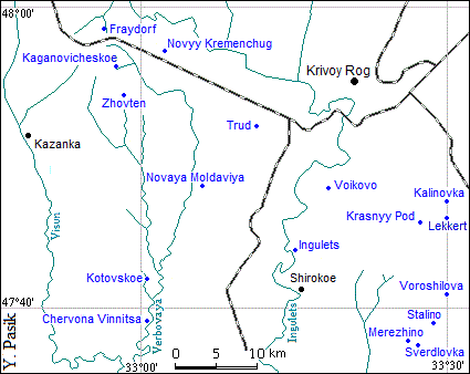
Map of Jewish agricultural settlements of district Krivoy Rog-Kazanka-Shirokoe
Table. Jewish agricultural settlements of district Krivoy Rog-Kazanka-Shirokoe
| Settlement name |
Location |
Settlement name
(data for 2016) |
| Chervona Vinnitsa (Red Vinnitsa), uchastok 36 |
N 47°39'01",
E 33°00'39" |
Bowery Vinnitsa Mikhaylovka village soviet Shirokoe rayon Dnepropetrovsk oblast (data 1946) does not exist now |
| Fraydorf, uchastok 30 |
N 47°58'27",
E 32°56'16" |
Village Slobodka Kashirovka village soviet Kazanka rayon Nikolaev oblast |
| Kaganovicheskoe, poselok 1 of uchastok 31 |
N 47°55'54",
E 32°57'11" |
Village Kaganovicheskoe Nikolo-Gulak village soviet Kazanka
rayon Nikolaev oblast (data 1946), then Veselovka. The Village does not exist now |
| Kotovskoe, uchastok 35, kolkhoz "Rekonstruktsiya" |
N 47°42'12",
E 33°00'15" |
Village Mirnoe (former Kotovskoe) Novomalinovka village soviet Shirokoe rayon Dnepropetrovsk oblast |
| Merezhino, poselok 4, Sverdlovka village soviet |
N 47°38'04",
E 33°25'48" |
Bowery Merezhino Sverdlovskoe village soviet Shirokoe rayon Dnepropetrovsk
oblast (data 1946), then village Tikhoe. The Bowery does not exist now |
Novaya Moldaviya (New Moldova), uchastok 33-58, kolkhoz "Nayleben" |
N 47°48'02",
E 33°05'43" |
Village Novaya Zelenaya Balka village soviet Shirokoe rayon Dnepropetrovsk oblast |
| Novyy Kremenchug (New Kremenchug), uchastok 63 |
N 47°56'57",
E 33°02'08" |
Village Novyy Kremenchug Geykovka village soviet Krivoy Rog rayon Dnepropetrovsk oblast |
| Stalino, poselok 2, Sverdlovka village soviet |
N 47°39'10",
E 33°28'37" |
Bowery Stalina Sverdlovskoeо village soviet Shirokoe rayon Dnepropetrovsk
oblast (data 1946), then village Tikhoe. The Bowery does not exist now |
| Sverdlovka, poselok 3, Sverdlovka village soviet |
N 47°37'31",
E 33°26'58" |
Village Spasskoe (former Sverdlovskoe) Blagodatnoe (former Chapaevka)
village soviet Shirokoe rayon Dnepropetrovsk oblast |
| Trud |
N 47°52'12",
E 33°11'09" |
Included in the village Zeleyyy Gay Danilovka (former Kirovo) village soviet Krivoy Rog rayon Dnepropetrovsk oblast |
| Voikovo, uchastok 56 |
N 47°48'02",
E 33°18'03" |
Bowery Voikovo Novyy Krivoy Rog village soviet Krivoy Rog rayon Dnepropetrovsk
oblast (data 1946) does not exist now |
| Voroshilova, poselok 1, Sverdlovka village soviet |
N 47°40'51",
E 33°30'18" |
Bowery Voroshilovka Sverdlovskoe village soviet Shirokoe rayon Dnepropetrovsk
oblast (data 1946) does not exist now |
| Zhovten, poselok 2 of uchastok 31 |
N 47°54'04",
E 32°58'19" |
Village Novyy (New) (former Zhovten) Novofedorovka
village soviet Kazanka rayon Nikolaev oblast | >
Note: The data on the Ingulets colony are given in the section "Colonies of the Kherson guberniya", and on the settlements Kalinovka, Red Pod and Lekkert - in the section "Stalindorf jewish national rayon".
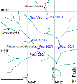
Map of Jewish agricultural settlements of district Bozhedarovka
Table. Jewish agricultural settlements of district Bozhedarovka
| Settlement name |
Location |
Settlement name
(data for 2016) |
| Nay Veg, poselok 101/2 |
N 48°09'04"
E 34°05'21" |
Village Ukrainskoe (former Oktyabrskoe) Guliaipole village soviet Krinichki rayon
Dnepropetrovsk oblast |
| Poselok 101/1 |
N 48°09'08",
E 34°08'33" |
Included in the Village Udachnoe Guliaipole village soviet
Krinichki rayon Dnepropetrovsk oblast |
| Poselok 101/3 |
N 48°06'23",
E 34°05'47" |
Village Pervomayskoe Guliaipole village soviet Krinichki rayon
Dnepropetrovsk oblast |
| Poselok 102/1 |
N 48°05'19",
E 34°06'57" |
Included in the Village Aleksandro-Belovka Nikolaevka village soviet
Sofievka rayon Dnepropetrovsk oblast |
| Poselok 102/2 |
N 48°05'01",
E 34°07'10" |
Included in the Village Aleksandro-Belovka Nikolaevka village soviet
Sofievkaо rayon Dnepropetrovsk oblast |
| Poselok 102/4 |
N 48°05'25",
E 34°10'51" |
Included in the Village Buzuluki Guliaipole village soviet
Krinichki rayon Dnepropetrovsk oblast |
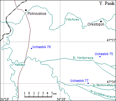
Map of Jewish agricultural settlements of district Pokrovskoe
Table. Jewish agricultural settlements of district Pokrovskoe
| Settlement name |
Location |
Settlement name
(data for 2016) |
| Uchastok 75 |
N 47°53'11",
E 36°27'08" |
Village Stepovoe village soviet Pokrovskoe rayon Dnepropetrovsk oblast |
| Uchastok 77, Smidorfsky |
N 47°50'03",
E 36°24'57" |
Bowery Vinogradnyy Berezovka village soviet Pokrovskoe rayon
Dnepropetrovsk oblast (data 1946) does not exist now |
| Uchastok 79 |
N 47°54'17",
E 36°14'46" |
Village Otradnoe Aleksandrovka village soviet Pokrovskoe rayon
Dnepropetrovsk oblast |
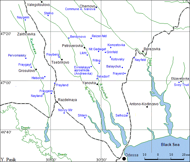
Map of Jewish agricultural settlements of the Odessa region
Table. Jewish agricultural settlements of the Odessa region
| Settlement name |
Location |
Settlement name
(data for 2016) |
| Balaychuk |
N 47°05'27",
E 30°42'26" |
Village Balaychuk Marinovka village soviet Berezovka rayon Odessa oblast |
| Berdynovo |
N 47°17'44",
E 30°10'32" |
Village Berdynovo Armashevka (former Ordzhonikidze) village soviet Shiryaevo rayon Odessa oblast |
| Evreiskaya agroshkola (Jewish Agricultural School), Andreevka |
N 47°06'14",
E 30°24'54" |
Village Mikhaylopol Mikhaylopol village soviet Ivanovka rayon Odessa oblast |
| Felixdorf (Kosenkovo, Kostakov) |
N 47°00'47",
E 30°27'48" |
Village Bogunovo Konoplyanoe village soviet Ivanovka rayon Odessa oblast |
| Frayberg |
N 47°06'30",
E 29°47'35" |
Included in the Settlement Tsebrikovo Tsebrikovo village soviet Velikaya Mikhailovka rayon Odessa oblast |
| Frayerd |
N 47°03'12",
E 30°44'20" |
Bowery Volnyy Balaichuk village soviet Berezovka rayon (data 1946)
included in the Village Kurisovo Limansky (former Kominternovo) rayon Odessa oblast |
| Fraygayt |
N 47°06'30",
E 29°47'35" |
Village Frasino Poleznoe village soviet Velikaya Mikhailovka rayon Odessa oblast |
| Fraygeim |
N 46°54'48",
E 30°00'10" |
Included in the Village Getmantsy Markovka village soviet Razdelnaya rayon Odessa oblast |
| Frayland |
N 46°59'06",
E 30°02'46" |
Included in the settlement Migaevo Migaevo village soviet Velikaya Mikhailovka rayon Odessa oblast |
| Friling |
N 47°07'06",
E 30°28'29" |
Village Vesennee (data 1946) included in the Village Anno-Pokrovka Katerino-Platonovka village soviet
Shiryaevo rayon Odessa oblast |
| Grinfeld (Shutovo) |
N 47°11'22",
E 30°32'42" |
Village Chervonobagovitsa Anatolyevkaского village soviet Zhovtnevoe rayon
Odessa oblast (data 1946) does not exist now |
| Hleborob |
N 47°01'48",
E 29°56'24" |
The locality does not exist now |
| Commune А. Ivanova |
N 47°30'03",
E 30°27'48" |
Village Andreevo-Ivanovka Andreevo-Ivanovka village soviet Nikolaevka rayon Odessa oblast |
| Komzetovka (In honor of the organization KOMZET) |
N 47°13'23",
E 30°35'39" |
Village Rovnoe Stavkovoe village soviet Berezovka rayon Odessa oblast |
| Kotovsky |
N 47°09'42",
E 30°35'37" |
Village Kotovka (former Kotovsky) Rastsvet village soviet Berezovka rayon Odessa oblast |
| Likht (Svet) |
N 47°10'28",
E 30°22'33" |
Included in the Village Sofievka Novoelizavetovka village soviet Shiryaevo rayon Odessa oblast |
| Nayfeld |
N 47°09'42",
E 30°49'22" |
Village Novoselovka Novoselovka village soviet Berezovka rayon Odessa oblast |
| Naygeim, artel Emes |
N 47°24'51",
E 29°44'53" |
Village Novohatki Novopavlovka village soviet Frunzovka rayon
Odessa oblast (data 1946) does not exist now |
| Nayland, artel "Trud i nashe buduschee" |
N 46°53'52",
E 29°55'39" |
Included in the Village Gaevka Gaevka village soviet Razdelnaya rayon Odessa oblast |
| Nit Gedaiget |
N 47°11'43",
E 30°28'40" |
Village Horoshilovka Katerino-Platonovka village soviet Zhovten rayon Odessa oblast (data 1946)
does not exist now |
| Novyy Mir (Novomirka, Neivelt) |
N 46°46'53",
E 30°08'15" |
Village Novyy Mir Kirovo village soviet Razdelnaya rayon Odessa oblast (data 1946) included in the Village
Pokrovka Kamenka village soviet Razdelnaya rayon Odessa oblast |
| Bowery Pervomaisky |
N 47°09'01",
E 29°45'55" |
Bowery Pervomaisky Soshe-Ostrovsky village soviet Velikaya Frunzovka rayon Odessa oblast (data 1946) does not exist |
| Colonies in the vicinity of Shtetl Petroverovka (Zinoviev or Zinovievo, "Raveystvo and Bratstvo", Trotskoe or Trotsk) |
N 47°13'48",
E 30°20'24" |
Village Petroverovka (former Zhovten) Petroverovka (former Zhovten) village soviet Shiryaevo rayon Odessa oblast |
| Reisenfeld, since 1929 Ratnfeld) |
N 47°17'15",
E 30°24'01" |
Village Polevoe Petroverovka (former Zhovten) village soviet Shiryaevo rayon Odessa oblast |
| Shtern (Millerovo, Miller) |
N 46°45'05",
E 30°20'08" |
Village Andreevo-Ivanovo Blagodatnoe (former Kirovo) village soviet Razdelnaya rayon Odessa oblast |
| Selhozar |
N 46°46'54",
E 30°45'23" |
Settlement Stepovoe Cremidovka village soviet Limansky (former Kominternovo) rayon Odessa oblast |
| Stalino |
N 47°26'47",
E 29°58'25" |
Bowery Stalino Valentinovka village soviet Shiryaevo rayon (data 1946) does not exist |
| Artel "Svoy Trud" |
N 46°58'55",
E 31°16'24" |
The locality does not exist now |
|
Points of near-Shtetl farming |
| Shtetl Chernovo |
N 47°30'03",
E 30°27'48" |
Village Andreevo-Ivanovka Andreevo-Ivanovka village soviet Nikolaevka rayon Odessa oblast |
| Shtetl Grosulovo |
N 47°04'41",
E 29°50'56" |
Settlement of urban typ Velikaya Mikhailovka Velikaya Mikhailovka settlement soviet Velikaya Mikhailovka rayon Odessa oblast |
| Shtetll Petroverovka |
N 47°13'48",
E 30°20'24" |
Village Petroverovka (former Zhovten) Petroverovka (former Zhovten) village soviet Shiryaevo rayon Odessa oblast |
| Shtetl Yanovka |
N 46°58'44",
E 30°27'52" |
Village Yanovka Lyubashevka rayon Odessa oblast |
| Shtetll Zakharyevka |
N 47°19'48",
E 29°45'09" |
Settlement of urban typ Zakharyevka (fortmer Frunzovka) Zakharyevka (fortmer Frunzovka)rayon Odessa oblast |
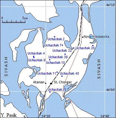
Map of the Jewish agricultural settlements of the Chongar Peninsula
Table. Jewish agricultural settlements of the Chongar Peninsula
| Settlement name |
Location |
Settlement name
(data for 2016) |
| Uchastok 1 |
N 46°05'28",
E 34°29'06" |
The locality does not exist now |
| Uchastok 2, Malomelitopol (Little Melitopol) |
N 46°06'01",
E 34°30'45" |
The locality does not exist now |
| Uchastok 4, Iskra |
N 46°04'23",
E 34°27'37" |
Village Stalinskoe Atamanskoe village soviet Genichesk rayon Kherson oblast
(data 1946), then village Stepovoe. The Village does not exist now |
| Uchastok 7 |
N 46°05'41",
E 34°32'22" |
The locality does not exist now |
| Uchastok 9, Zorka |
N 46°04'04",
E 34°27'44" |
Village Stalinskoe Atamanskoe village soviet Genichesk rayon Kherson oblast
(data 1946), then village Stepovoe. The village does not exist now |
| Uchastok 10, Obschestvennyy Trud № 2, kolkhoz "Rote Stern" |
N 46°03'48",
E 34°30'27" |
Village Chervona Zirka Atamanskoe village soviet Genichesk rayon Kherson oblast
(data 1946) does not exist now |
| Uchastok 11, Gaydy or Geydy |
N 46°02'31",
E 34°31'38" |
The locality does not exist now |
| Uchastok 15 |
N 45°59'51"
E 34°30'51" |
The locality does not exist now |
| Uchastok 22, Gorbatok, kolkhoz "Rote Fane" |
N 46°04'56",
E 34°34'34" |
Village Krasnoe Znamya Nikolaevka village soviet Genichesk rayon Kherson oblast
(data 1946) does not exist |
| Uchastok 26 |
N 46°05'28",
E 34°37'52" |
The locality does not exist now |
| Uchastok 39, kolkhoz "Novyy Trud" |
N 46°04'38",
E 34°33'18" |
Village Novyy Trud Chongar village soviet Genichesk rayon Kherson oblast |
| Uchastok 40, Smidovichi, kolkhoz "Sotsput" |
N 46°01'49",
E 34°32'44" |
Village Chongar (former Sotsput) Chongar village soviet Genichesk rayon Kherson oblast
|
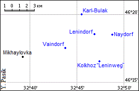
Map of the Jewish agricultural settlements of the Lenindorf Village Council of the rayon Skadovsk
Table of the Jewish agricultural settlements of the Lenindorf Village Council of the rayon Skadovsk
| Settlement name |
Location |
Settlement name
(data for 2016) |
| Karl-Bulak |
N 46°20'12",
E 32°45'24" |
Village Promin Mikhaylovka village soviet Skadovsk rayon Kherson oblast |
Lenindorf
(former Leninskoe, in 1941-1943 - Novovyzvolne) |
N 46°18'40",
E 32°46'47" |
Village Karabulat (former Leninskoe) Mikhaylovka village soviet Skadovsk rayon Kherson oblast |
| Kolkhoz Leninweg |
N 46°16'37",
E 32°47'20" |
Village Belenkoe Mikhaylovka village soviet Skadovsk rayon Kherson oblast |
| Naydorf |
N 46°18'38",
E 32°48'46" |
Village Novoselka Mikhaylovkaо village soviet Skadovsk rayon Kherson oblast |
| Vaindorf |
N 46°17'35",
E 32°43'38" |
Village Trud Mikhaylovka village soviet Skadovsk rayon Kherson oblast |
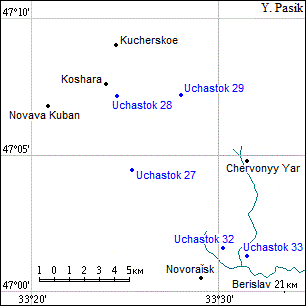
Map of Jewish agricultural settlements north of Berislav
Table. Jewish agricultural settlements north of Berislav
| Settlement name |
Location |
Settlement name
(data for 2016) |
| Uchastok 27 |
N 47°04'24",
E 33°25'22" |
The locality does not exist now |
| Uchastok 28 |
N 47°07'13",
E 33°24'31" |
The locality does not exist now |
| Uchastok 29 |
N 47°07'16",
E 33°27'55" |
The locality does not exist now |
| Uchastok 32 |
N 47°01'37",
E 33°30'13" |
The locality does not exist now |
| Uchastok 33 |
N 47°01'20"
E 33°31'26" |
Village Zamozhnoe Novoraisk village soviet Berislav rayon Kherson oblast |
Table. Separately located Jewish agricultural settlements
| Settlement name |
Location |
Settlement name
(data for 2016) |
| Chervony (Erdarbayter) |
N 46°09'49",
E 35°27'53" |
Village Novoaleksandropol Slavgorodого village soviet Sinelnikovo
rayon Dnepropetrovsk oblast |
| Frayland (southwest of Novopoltavka) |
N 47°31'48",
E 32°28'22" |
The locality does not exist now |
| Frayleben |
N 48°21'17",
E 34°04'16" |
Village Privolnoye Katerinopol village soviet Krinichki rayon Dnepropetrovsk oblast |
| Krasindorf |
N 47°51'56",
E 34°29'57" |
Village Krasino Lukievka village soviet Nikopol rayon
Dnepropetrovsk oblast (data 1946) does not exist now |
| Slava, kolkhoz "Novaya Zhizn" |
N 47°36'02",
E 31°08'22" |
Bowery Slava Novokantakuzovka village soviet Domanevka rayon Odessa oblast (data 1946) does not exist |
| Uchastok 34 (Kaganovich) |
N 46°40'43"
E 32°22'41" |
Village Zorevka Nadezhdovka village soviet Belozerka rayon Kherson oblast |
| Uchastok 35 |
N 46°42'21"
E 32°23'35" |
Village Znamenka Nadezhdovka village soviet Belozerka rayon Kherson oblast |
Names of the separate Jewish agricultural settlements of Southern Ukraine founded in 1920-1930
1. Most of the separate Jewish agricultural settlements had names in Yiddish:
Emes (True), Erdarbayter (Farmer), Frayberg (Free Mountain), Fraydorf (Free village), Frayerd (Free Land), Fraygayt (Freedom),
Fraygeim (Free Homeland), Frayland (Free Country), Friling (Spring), Grinfeld (Green Field), Leninweg (Lenin's way), Likht (Shine),
Naydorf (New Village), Nayfeld (New Field), Naygeim (New Homeland), Nayland (New Country), Nayleben (New Life), Nay Veg (New Way),
Neivelt (New World), Nit Gedaiget (Cheer Up!), Ratnfeld (Red Field), Rote Fane (Red Flag), Rote Stern" (Red Star), Shtern (Star),
Vaindorf (Wine Village).
2. Part of Jewish settlements was named after Revolutionaries and Soviet political and military leaders:
Ivanov A.V., Kaganovich L.М., Kotovsky G.I., Krasin L.B., Lenin V.I., Petrovsky C.I., Smidovich P.G., Stalin I.V., Sverdlov Y.V.
Trotsky L.D., Voikov P.L., Voroshilov K.E., Zinoviev G.E.
3. Several settlements was named after Jewish figures: Abram Raisen, Felix Warburg, Abtam Merezhin.
4. Several settlements had Russian and Ukrainian names. For example, Hleborob (Agriculturist),
Iskra (Spark), Nashe buduschee (Our future), Obschestvennyy Trud (Social Labor), Novaya Zhizn (New Life), Novyy Trud (New Labor),
Promin (Ray), Raveystvo and Bratstvo (Equality and Brotherhood), Rekonstruktsiya (Reconstruction), Sotsput (Socialist way),
Svet (Shine), Slava (Glory), Svoy Trud (Own Labor), Trud-Schaste (Labor-Happiness), Zhovten (October), Zorka (Dawn).
5. Some settlements are named with numbers of the plots (uchastok, shortened uch.) on which they were
located.
31-07-2009 |